If you ever read James Cook’s diary for Wednesday the 22nd day of August 1770 when on Possession Island he took possession of a large chunk of the eastern coast of what was at that time Terra Australis for King George 3rd and you were paying attention, you would have immediately recognise a really weird thing, James Cook claimed the eastern coast line between the latitude 38° south and 10°43 minutes South (Roughly from the bottom of Victoria to almost the top of Queensland)
But that is a line not an area and was only recently that I discovered the reason for what seemed to be a such a very obvious oversight/omission and so uncharacteristically like a person who was extremely pedantic in recording information.
The reason goes all the way back to the 15th century when Portugal and Spain were the two European superpowers (Much like China and the United States of America are today) and were gobbling up colonisation of land throughout the planet as a consequence of their increased maritime capabilities and technological advancement.
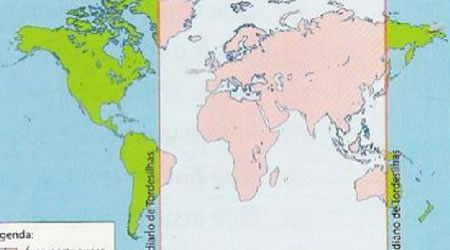 At that stage they believed the world was flat so in order to avoid a conflict of the giants over the this massive land grab, which would have done neither nation any good, these two super powers entered into an agreement (Treaty of Tordesillas) and apparently both nations being Roman Catholic countries the agreement was ratified by the Pope in 1494.
This is why Brazil is the only Portuguese-speaking country in South America as the longitude cut off a slice from the otherwise Spanish nations of South America
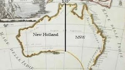
By the mid-17th century the Dutch via the medium of the Dutch East India Company was also growing in national wealth and capability and in 1644 Abel Tasman sailed the western coast of Terra Australis naming and claiming the portion of the continent from the coast over to longitude 135° East.
This longitude was the longitude put in place by the Treaty of Tordesillas in which lands to the west of that longitude could be claimed by Portugal and lands to the east of that longitude could be claimed by Spain. But in 1644 Portugal was having its own problems and its power was in decline, so apparently the Dutch felt competent enough to impinge on Portugal’s rights, but not Spain’s.
By 1770 the balance of power in Europe had continued to change, significantly Britain’s naval power was rising to the ascendancy and Spain’s power by now was also in decline.
I think, but can’t find any evidence to support this statement, but it seems pretty obvious that James Cook got his instructions from the King George III that in claiming the Spanish part of land in Terra Australis all he just need to was attend to the latitude bit as the longitudinal bit had already been settled (i.e. from the coast, west to longitude 'I35° East' - the current Spanish bit) thereby leaving the Dutch (New Holland) portion which they had stolen from the Portuguese in 1644, intact (i.e. west from longitude '135°East' to the coast)
It was the the United Kingdom of Great Britain and Northern Ireland (Britain-British) who created the first land boundary on Australian soil in 1786 - at the western border of NSW with South Australia.
And if you look a bit further north, to the border of Papua New Guinea and West Papua, you'll notice the dividing lines are perfectly aligned with those in Australia. This is because the first state (NSW) border was actually based on the Treaty of Tordesillas.
In a Public Lecture Series a Dr Gerard Carney, a leading expert on Australia's constitutional, said that when Dutch explorer Abel Tasman named only the western half of the new continent as New Holland in 1644 but leaving the eastern half of the country as Terra Australis as this eastern part of the country was in term of the Treaty within the control of Spain and would have don this in order to avoid conflict with Spain, which at the time Holland was fighting for its independence..
According to Dr Carney this longitude 135° East boundary was later used by the British so they didn't offend the Dutch becuase "Although priority was given in 1788 to ensuring no offence to the Dutch, the British remained mindful of the Spanish claim to Terra Australis and, in particular, to Spain's claim of exclusive sovereignty and navigation rights in the Pacific,".
This same meridian was also used to divide up the disputed island of New Guinea amongst the colonial powers, with the west half of the island governed by the Dutch and the British and Germans vied for control in the East although the western half is now part of Indonesia, while the eastern half forms the bulk of the independent state of Papua New Guinea, including the Bismarck Archipelago and a number of smaller islands.
 Dr Carney says our current state borders look different to other countries because histroically borders were usually determined by natural geography features such as mountain ranges, rivers, lakes, gorges, or deserts. whie all of these features have played some role in the drawing of Australia's boundaries," their role has been a secondary one on the mainland due to the extraordinary distances involved, and the fact that the internal geography of the continent was largely unknown at the time the Britain define colonies borders in former Terra Australis and New Holland areas.
However in the 1770 the claimed area by James Cook for Britain of 'New South Wales' was massive, comprising almost half of the continent excluding only New Holland and Van Diemen's Land.
The Free Swan River Colony in 1929 was the second to be esatblished and named Western Australia in 1832. Then the colony of South Australia, created by and for free settlers in 1836, being the third, followed by the Colony of New Zealand in 1840 and the Colony of Victoria in 1851 and finally the Colony of Queensland in 1859..